In East Kentucky, Timely Weather Forecasts Are a Matter of Life and Death
Weather alerts can save lives — but you have to have a good internet connection.
|
Listen To This Story
|
This story is a collaboration between The Daily Yonder and Grist, and is part of Covering Climate Now, a global journalism collaboration strengthening coverage of the climate story. For more, watch the Daily Yonder’s video “How Broadband and Weather Forecasting Failed East Kentucky.”
Terry Thies wasn’t worried about the rain that pounded on her roof last July.
She had received no flood warnings before going to sleep that night. Besides, her part of rural Perry County in eastern Kentucky often gets heavy rain.
So early the next morning when her foot hit the water lapping the bottom of her wooden bed frame, Thies’s first thought was that the toilet had overflowed. But as she scanned her bedroom for the water’s source, she realized this was something else entirely.
“I came into the kitchen and opened the door and water was flowing down the lane,” Thies said. “Water was in my yard and rushing down. And I was like, well, I guess I’ve been flooded.”

In the days leading up to the storm, the National Weather Service predicted heavy rain and a moderate risk of flooding across a wide swath of eastern Kentucky and West Virginia. What happened instead was a record-breaking four-day flood event in eastern Kentucky that killed a confirmed 43 people and destroyed thousands of homes.
And though the National Weather Service issued repeated alerts, many people received no warning.
“Not a soul, not one emergency outlet texted me or alerted me via phone,” Thies said.
“Nobody woke me up.”
Thies’s experience in the July floods reveals troubling truths about Kentucky’s severe weather emergency alert systems. Imprecise weather forecasting and spotty emergency alerts due to limited cellular and internet access in rural Kentucky meant that Thies and many others were wholly unprepared for the historic flood.
Efforts to improve these systems are underway, but state officials say expansions to broadband infrastructure will take at least four years to be completed in Kentucky’s most rural counties. In a state where flooding is common, these improvements could be the difference between life and death for rural Kentuckians.
But there’s no guarantee they’ll come before the next climate change-fueled disaster.
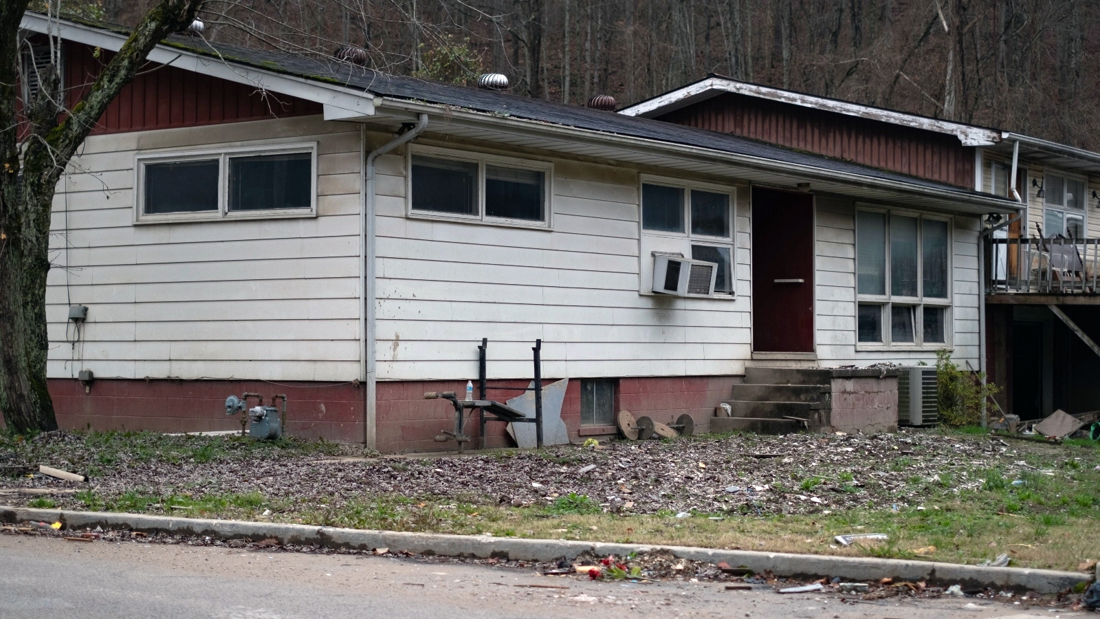
The first system that failed eastern Kentuckians in July was the weather forecasting system, which did not accurately predict the severity of the storm. A built-in urban bias in weather forecasting is partially to blame.
“Did we forecast [the storm] being that extreme? No, we didn’t,” said Pete Gogerian, a meteorologist at the National Weather Service station in Jackson, Kentucky, which serves the 13 eastern Kentucky counties affected by the July floods.
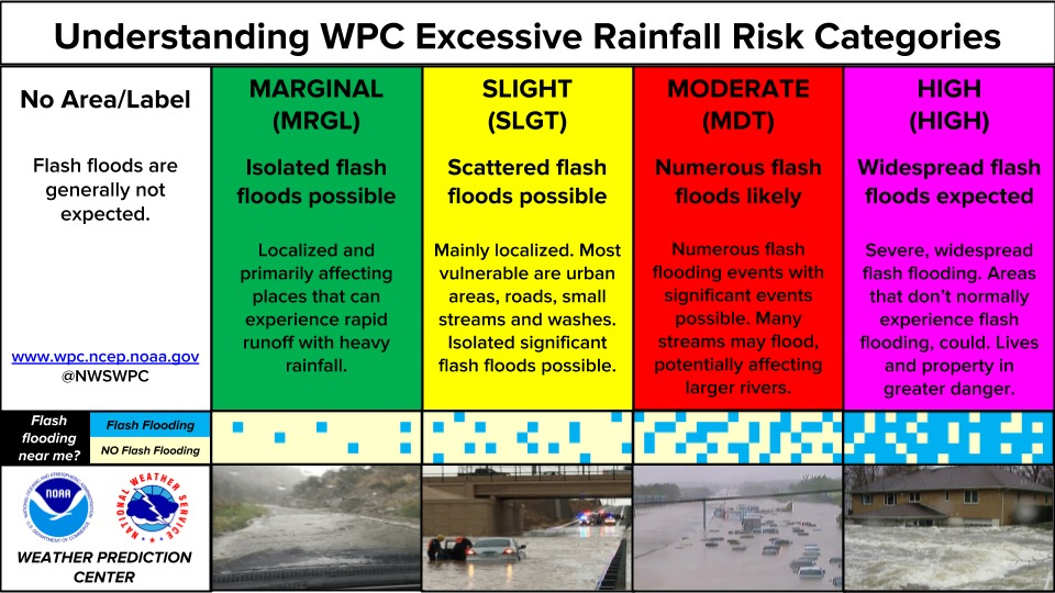
For the days preceding the storm, the Jackson station warned of a “moderate risk” of flooding across much of their service area. Observers with the benefit of hindsight might argue that a designation of “high risk” would have been more appropriate. But Jane Marie Wix, a meteorologist at the Jackson station, wrote in an email to The Daily Yonder that the high-risk label is rarely issued, and simply didn’t match what the model was predicting for the July storms.
“When we have an event of this magnitude, we’ll go back and look at, are there any indicators? Did we miss something? Was there really any model predicting this kind of event?” Gogerian said. “But when you looked at [the flooding in] eastern Kentucky, it just wasn’t there.”
“I don’t think anyone could have predicted just how bad it was going to end up being,” Wix wrote.
Wix says the moderate risk warning was enough to warn people that the storm could have severe impacts in many locations. But the model’s inaccuracy demonstrates a flaw in the National Weather Service forecasting model system that was used at the time of the flood.
Extreme weather is hard to predict in any setting, but rural regions like eastern Kentucky are at an additional disadvantage due to an urban bias baked into national weather forecasting systems, according to Vijay Tallapragada, the senior scientist at the National Weather Service’s Environmental Modeling Center.
Forecasting models depend on observational data — information about past and present weather conditions — to predict what will come next. But there’s more data available for urban areas than for rural areas, according to Tallapragada.
“Urban areas are observed more than rural areas … and that can have some, I would say, unintended influence on how the models perceive a situation,” he said.
Although spaceborn satellites and remote sensing systems provide a steady supply of rural data, other methods of observation, like aircraft and weather balloons, are usually concentrated in more densely populated areas.
“Historically, many weather observations were developed around aviation, so a lot of weather radars are located at major airports in highly populated cities,” said Jerry Brotzge, Kentucky state climatologist and director of the Kentucky Climate Center. “That leaves a lot of rural areas with less data.”
Weather prediction models are based on past events, so the lack of historical weather data in rural areas poses a serious challenge for future predictions, according to Brotzge. “For large areas of Appalachia, we just don’t know the climatology there as well as, say, Louisville or some of the major cities,” he said.
This lack of current and historical weather observation can leave rural areas vulnerable to poor weather forecasting, which can have catastrophic results in the case of extreme weather events.
A new forecasting model, however, could close the gap in rural severe weather prediction.
The new Unified Forecast System is being developed by the National Weather Service and a group of academic and community partners. The modeling system is set to launch in 2024, but the results so far are promising, according to Tallapragada.
“In the next couple years, we will see a revolutionary change in how we are going to predict short-range weather and the extremes associated with it,” he said.
The problem with the current system, said Tallapragada, is that it depends on one model to do all the work.
A new application called the Rapid Refresh Forecast System is set to replace that single model with an ensemble of 10 models. Using multiple models allows meteorologists to introduce more statistical uncertainty into their calculations, which produces a broader, and more accurate, range of results, according to Tallapragada. He said that although the new system is not yet finished, it has already proven to be on par with, or better than, the current model.
The Rapid Refresh Forecasting System will mitigate the disparity between urban and rural forecasting because it depends more on statistical probabilities and less on current and historical observational data, which is where the biggest gap in rural data currently lies, according to Tallapragada.
The system could also mean improved accuracy when it comes to predicting severe weather, like Kentucky’s July flood event.
“The range of solutions provided by the new system will capture the extremes much better, independent of whether you are observing better or poorly,” Tallapragada said. “That’s the future of all weather prediction.”
As extreme weather events become more common due to climate change, this advancement in weather forecasting has the potential to transform local and regional responses to severe weather. But without massive investments in broadband, life-saving severe weather alerts could remain out of reach for rural communities.
Over a year before the July 2022 floods devastated eastern Kentucky, some counties in the same region were hit by floods that, while not as deadly, still upended lives.
“There were no warnings for that flood,” said Tiffany Clair, an Owsley County resident, in a Daily Yonder interview. “It was fast.”
Clair received no warning when extreme rains hit her home in March of 2021, which severely damaged nearby towns like Booneville and Beattyville. “I did not think that those [towns] would recover,” Clair said.

Businesses and homes were impaired for months after the flood, affecting not only the people in those communities but those from neighboring communities as well.
“We live in a region where we travel from township to township for different things, and [the March 2021 floods] were a blow to the region and to the communities, because we’re kind of interlocked around here,” Clair said. “It’s part of being an eastern Kentuckian.”
A little over a year later, Clair faced more flooding, this time enough to displace her and her children. They now live with Clair’s mother.
This time around, Clair did receive an emergency warning, but questioned the method through which these warnings were sent. “[The warnings] did go all night, the last time, in July,” Clair said. “But if you don’t have a signal or if your phone’s dead, how are you getting those?”
During severe weather events, people are alerted of risk through a handful of ways. Weather information reported from regional National Weather Service offices is disseminated through local TV and radio stations, specialized weather radios, and the Federal Emergency Management Agency’s wireless emergency alert system, which requires cell service to deliver.
But in rural eastern Kentucky in July, the most common way people learned about the flooding was by seeing the water rise firsthand, according to a report from the Kentucky Department of Public Health.
The agency surveyed people from over 400 households in Breathitt, Clay, Floyd, Knott, Letcher, Owsley, and Perry counties, as well as displaced residents living in three shelter sites. The goal of the study was to understand how the floods affected Kentuckians and determine ways to better prepare for the next emergency.
Nearly 14 percent of households in Letcher, Knott, Owsley, and Perry counties and 28 percent of households in Breathitt, Clay, Floyd, and Pike counties reported difficulty accessing internet, television, radio, and cell service for emergency communications during the floods. Cell phone service and internet access were the top two communication methods residents reported the most difficulty accessing.
The floods killed a confirmed 43 people: 19 from Knott County, 10 from Breathitt, seven from Perry, four from Letcher, two from Clay, and one from Pike County. Several more people died after the floods due to related health complications.
In Knott and Breathitt County, where death counts were the highest, approximately 32 percent of residents do not have broadband access, according to US Census Bureau data. And in 10 of the 13 counties flooded in July, more than a quarter of residents lack broadband access.
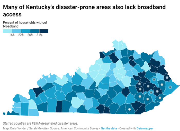
Rural areas across the country are underserved when it comes to broadband, but eastern Kentucky is a special trouble spot, where high costs to serve rural customers have stopped internet companies from setting up broadband in rural areas. In 2017, Kentucky ranked 47th in the nation for broadband access, according to the Kentucky Communications Network Authority.
“There’s a lot of frustration because a lot of these internet service providers are profit-based companies,” said Meghan Sandfoss, executive director of the state’s newly created Office of Broadband Development. “So it’s hard for them sometimes to make a business case for the more remote and low-density locations.”
The state’s effort to expand broadband has sputtered for years due to missteps by government officials, according to ProPublica reporting. An internet connectivity project, KentuckyWired, was launched in 2013 with the goal to construct 3,000 miles of high-speed fiber optic cable in every Kentucky county by 2018. The project didn’t reach its final steps until fall of 2022, according to a KentuckyWired construction map.
Getting the cable laid down is only one part of the process: for individual households and businesses to actually access the internet, third-party providers need to connect their own fiber systems to the network, according to the Kentucky Communications Network Authority. This “last-mile” infrastructure is critical to broadband expansion, but progress has been slow.
“That might be another 10 years or 20 years while all that last-mile stuff gets built,” said Doug Dawson, a telecommunications consultant, in a ProPublica interview from 2020.
To speed up this process, both the state and federal governments have recently directed funds toward improved internet connectivity and last-mile infrastructure.
In June of 2022, Kentucky Governor Andy Beshear announced a $203 million investment in last-mile infrastructure funded through the American Rescue Plan Act. Another $20 million of grants was opened in September for broadband providers to replace utility poles that provide connectivity in underserved areas. And early this year, another $182 million in federal funding was awarded to fund Kentucky’s “Better Internet” grant program.
This grant program is focused on making it more commercially feasible for private internet providers to reach rural areas, said Sandfoss from the Office of Broadband Development. The priority is to build broadband infrastructure in unserved locations where there is no internet, versus under-served locations with limited internet access.
“A frustration we hear frequently is that all these new locations are being connected and everybody else has to wait,” Sandfoss said. “But that’s just the federal funding priority, and that’s the way we’ve got to do it.”
Construction on the state’s broadband infrastructure expansions is expected to occur over the next four years.
As extreme weather continues to batter rural Kentucky — floods in February killed one person in rural Marion County — some locals aren’t waiting for governmental changes to better protect themselves in the face of disaster.
Terry Thies, whose childhood home was flooded in July, has decided to sell her house.
“Now that it has flooded, it will probably flood again,” Thies said. She plans to move up the mountain, away from the creek that damaged her home. “I just don’t wanna go through it again.”
But for Kentuckians who don’t have the financial means to move away from higher-risk flood areas, they may be stuck in place. Eastern Kentucky is in the middle of a major housing crisis: affordable housing is sparse, buildable land outside flood zones is limited, and construction costs for new homes can be prohibitively expensive.
“[The flood] was horrible, but we were very, very lucky,” said Tiffany Clair, whose home was destroyed in the July flood. Clair and her children were able to move in with her mother when they lost housing. “But the next time I don’t think we’ll be that lucky.”
Clair believes that rural Kentucky’s ability to withstand the next natural disaster hinges on the actions taken by local and state leaders.
“We can’t do anything to prepare for it. It is going to take our leaders, it is going to take our politicians,” she said.
“They’re the ones that have to prepare for it because we can’t.”
Additional reporting by Caroline Carlson and Xandr Brown.
