For centuries, Native Americans in the nation’s northernmost city, Utqiagvik, AK, have handled whatever nature threw their way. Climate change is making adaptation and resilience much harder. This story is Part 1 in a series about how climate change is affecting towns across America.
This story is part of WhoWhatWhy’s seven-part series about how climate change is affecting towns across America. Each member of our reporting team “adopted” a town; looked into the climate-caused problems it faces, from floods to fires; asked local experts and residents about unusual weather patterns they’ve witnessed; and quizzed town officials about any plans they have to address the challenges posed by a warming world.
———
For decades each spring, whaling captain Gordon Brower has navigated a dizzying icescape off the coast of Utqiagvik, the northernmost city in the United States, to provide food for his community.
Pressed against the Chukchi Sea in northern Alaska, Utqiagvik (pronounced oot—kay-ahg—vik) is home to 4,500 residents largely of Inupiat ancestry. Without year-round road access, almost all visitors to the city, formerly known as Barrow, fly into the local airport, though a few brave souls arrive by driving a snowmobile or ATV over the tundra. Seasonal barge traffic brings in fuel and heavy equipment, but isolation from the supply chain the rest of the year can hike grocery prices to almost triple those in the lower 48.
Members of Brower’s crew snowmobile down a network of trails that cuts through mountainous ice ridges and finally spits the men out at the edge of the Chukchi Sea. They set up camp behind a canvas windbreak, fastening harpoons to the barrel of darting guns that pack explosive-tipped projectiles. There’s a shoulder gun for backup. Sealskin boats perch at the edge of the ice, their noses pointed toward the dark Arctic Ocean. The instant a bowhead whale breaks through the surface near the crew’s camp, it’s go time.
“Whaling is a very dangerous, dangerous activity,” said Brower. Hunters in 20-foot boats confront bowheads up to 60 feet long and weighing up to 80 tons. One-third of the whale’s body is pure head, crested around a blowhole with a hump of dense fibrous tissue that can break ice one foot thick. In the spring of last year, a whale that Brower’s men had latched onto via harpoon capsized their boat. A search and rescue team took more than an hour to come in while hypothermia took hold of the crew. The physical stress and mental toll kept Brower and his men off the ice this spring, but as is customary in Inupiat culture, they shared in the whales that, as the locals say, gave themselves for harvest to other hunters.
Encountering a bowhead whale is daunting enough, but the ice terrain poses additional risks. To the uninitiated, the landscape looks simply white, but to Brower and his crew, longtime Utqiagvik residents and members of a long line of subsistence hunters, ice is ever-changing and unpredictable.
Several dozen Inupiat terms describe its many features: its age, the stable patches anchored to shore, benign vs. alarming cracks, and the thick slabs strong enough to carry a whale’s weight. It’s the language of an intimate relationship, forged through countless spring seasons the whaling crews spend out on the ice, always with an exit strategy in case of emergency.
By adapting to this variable seascape, the Inupiat have sustained their subsistence whaling for millennia, always handling what nature threw their way. But in the last few decades, climate change has confronted Utqiagvik’s residents with a new set of challenges.
Sea Ice Is Disappearing
“Ice has changed substantially over the course of 30 to 40 years,” said Brower, whose observations are confirmed by the National Snow and Ice Data Center, which has been tracing an increasingly severe loss of summer sea ice since satellite imagery started keeping track in the late 1970s. Three-quarters of Arctic sea ice has already vanished, and the remnants are projected to be completely gone during the Arctic summer within the next 15 years, under the pressure of temperatures that in the Arctic are climbing at more than twice the average global rate. Over the past 20 years, average temperatures in Utqiagvik in December have increased by 4.7 degrees F.
Brower has witnessed the decline of sea ice since he started whaling when he was about 10 years old, in 1973. Today, multiyear ice, thick enough that whalers can carve ramps into it for hauling a landed whale, is especially hard to come by. The ice doesn’t offer reliable footing anymore, and crews need to stay ever vigilant.
Younger and therefore weaker ice doesn’t anchor as firmly to the shore and breaks away more easily from the coastline. During the 1990s, Brower recalled, some 300 whalers weathered such breakout events, adrift on ice that had detached from the shore and kept shattering while heading out to sea. “Nowadays when we’re doing our whaling activities it’s single-season ice,” said Brower. Just 15 years ago, spring whalers had 10 to 15 miles of shore-fast ice to traverse on their way to the Chukchi Sea. When Brower ventures out these days, there’s barely two miles left. Out at his camp he can take a step away from the ice edge, turn around, and spot downtown Utqiagvik bare-eyed. He has taken to using NASA’s real-time satellite imagery to observe ice conditions; to help other whalers, he posts on Facebook anything that looks worrisome. Technology like this, Brower believes, will be particularly important for young people, who face an Arctic in constant and rapid flux as they learn to whale.
Peering back at Utqiagvik from his camp-on-ice during the spring hunt, Brower also knows that come the fall storm season, the city will likely face twin problems: floods and erosion. Both take a toll when the shore is iceless and exposed. Any anchored or even drifting ice buttressing the coast would protect against incoming waves and high winds, but these days freeze-up may not happen until December, far later than the early October freezes of a few decades ago.

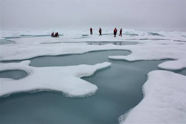
Sea ice melts off of Utqiagvik. Summer Arctic sea ice could be gone as early as 2035. Credit: Photo credit: NASA / Kate Ramsayer
“Spring thawing of the ice and snow is much quicker. The freezing of ocean, lakes, and rivers is much later than before,” said Harry Brower Jr., Gordon’s cousin and mayor of the North Slope Borough, the county whose seat is Utqiagvik. As a whaling captain himself, he’s had a frontline view of changes to what’s called the shoulder season.
So has Timothy Russell, general manager at Barrow Utilities & Electric Cooperative. “If we’ve got a good shoreline ice, that really protects us a bunch,” he said. “If we don’t have shoreline ice and we have a storm, the waves come in and wash right onto the beach. And they’re powerful, of course, and any sand or gravel that’s in there, if you work it hard enough, it’s going to be washed away.”
The persistent push and pull of waves erodes just over one foot of shore per year on average, although a single storm can chew up as much as 35 feet. In the southwestern reaches of the city, where some houses perch seven feet from the edge of bluffs, six homes are in danger of slipping into the sea. Just a few blocks south, the runway at Post/Rogers Memorial Airport will be threatened within the next 25 years. Efforts to replenish the beach with scooped-up ocean sediment were dealt a serious blow in 2000 when a storm sank the city’s main dredging barge.
“Right in front of my house we used to be able to park two pickup trucks end-to-end on the other side of the road and still go out there and sit in your truck or look over the side and watch whale swim by,” said Mike Shults, who’s been living in Utqiagvik for almost 50 years. “I can’t even walk on that now, it’s so close to falling into the ocean.” After a lifetime as an inveterate jack-of-all-trades, Shults is now fending off retirement by showing tourists around town.
One of his sightseeing stops is the Top of the World Hotel. It’s one row of houses removed from the coast, where an arch made from 14-foot whale jawbones frames an ocean view that offers prime postcard material.
Like Shults, Russell keeps his eye on that particular area, although his trips there are usually for business, not pleasure.
“Down in front of the old Top of the World Hotel and Stevenson Street [the town’s two-lane gravel road], that area gets hit every time we have a fairly large storm,” Russell said. He worries especially about Pump Station 4, one of nine stations throughout the city that pipe sewage from underground to higher elevations and on to a waste treatment plant. Every once in a while ice packs rush in and bury the little pilot house covering the pump station so that crews need to excavate it. But the big worry is water. “Pump station 4 was always a great concern for us. Having a large amount of water come in and pour onto it or into it and short everything out,” explained Russell. “If it fills with water, we’re doomed, we’re done.”
Russell and his team already raised Pump Station 4 by 3.7 feet in 2017, the same year a storm surge caused millions in damage and prompted a federal disaster declaration that authorized FEMA funds for repairs.
A pump station inundated with water would also spell trouble for other connected utilities. The station reaches down to the utilidor, a wooden tunnel that stretches 3.2 miles underground and bundles piping for potable water, sewage, telephone lines, and fiber optic, TV, and electrical cables.
Inspectors walk the utilidor’s length every day to check lines and keep the city’s vital signs in the clear. It’s one of the most expensive utility services ever built, per capita, second only to the International Space Station. Its $800 million price tag was covered largely by revenue from the oil fields at Prudhoe Bay 200 miles east. Kept at a constant 50 degrees F, the utilidor holds up well against the permafrost.
To shield seaward pump stations and other critical infrastructure, the county administration at the North Slope Borough has increasingly fortified Utqiagvik’s line of defense. In the last three years, the borough has installed thousands of “supersacks” loaded with 1 to 2 tons of gravel along the beach near the Top of the World Hotel and has placed steel baskets packed with backfill farther down the coast. These hefty embankments joined a sacrificial berm — one that will not provide permanent protection — made up of loose gravel and sand that already lined 3 miles of Utqiagvik’s coast. The entire package needs repairs every year at a cost of about $8.7 million.
A Much-Needed College Is Flooding
Travel north, past the Top of the World Hotel, the Latter-Day Saints church, and the only gas station in town, and in three miles you reach Ilisagvik College.
Ilisagvik is the only federally recognized tribal college in Alaska, one of a network of a few dozen tribally controlled colleges offering low-cost education to indigenous people. It is housed in the Naval Arctic Research Laboratory, a complex built in the 1940s to support military personnel and research scientists. The main campus building looks like an H-beam on end and is set on pilings that sit atop the permafrost. Massive Quonset huts host classes in industrial tech and carpentry, heavy truck and equipment operations, and welding and electrical work. These sit squeezed between the Arctic Ocean, a saltwater sewage lagoon, an old power plant, and waste disposal sites, the Navy’s old stomping grounds.

The skull of a bowhead whale sits in front of the main building at Iḷisaġvik College. Photo credit: Dave Cohoe / Wikimedia (CC BY-NC-ND 2.0)
“In rural regions you don’t have a lot of infrastructure to begin with,” said Pearl Brower, Harry Brower’s niece, who until last year was president of the college. “It was a space that was available and large enough that could house the type of activities that needed to go on.”
Brower said she misses the time when, five years ago, she could drive up Stevenson Street to the college without the sacrificial berm obstructing the ocean view. But even with the barrier in the way, storm floods wash out Stevenson Street and force the campus to shut down three or four days each year. The facilities are not hooked up to the utilidor system, and whenever the school loses road access it’s cut off from the trucks that carry potable water in and sewage out every day. Without access to fuel, groceries, or police and hospital services, students must be evacuated.
College authorities have been planning a permanent relocation even as the North Slope Borough has been pushing to get federal support for a more permanent seawall. A request in 2010 fell on deaf ears because the US Army Corps of Engineers didn’t deem Utqiagvik’s infrastructure worth saving, but the corps reconsidered in 2019. It is designing a 5-mile seawall made up of rock revetments and berms, and it plans to raise Stevenson Street by 14.5 feet. The total cost, $330 million, is to be split 35 to 65 percent between the borough and the federal government.
The project is still in an early planning stage, with core samples to be taken, ocean access points to be located, and building materials to be sorted out. Meanwhile, some residents are holding their breath. “If another storm surge hits at 60 to 80 mph someday, our community is going to be in serious trouble,” said Robin Mongoyak, an Utqiagvik resident. “And it seems as though we’re just waiting for it to happen.”


